Stuttgart AFB
AR-11
Ulm, AR 72170
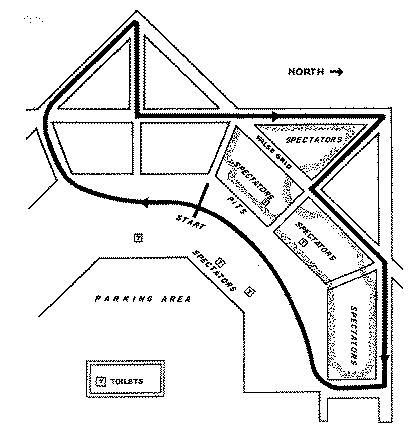
The map presently available is:
An outline of this course also appears on the Google Map image.
', trackImage => '', terraServerLink => 'http://terraserver.microsoft.com/image.aspx?T=1&S=13&Z=15&X=394&Y=2392&W=1&qs=%7cStuttgart%7cAR%7c', googleMapLink=>'http://maps.google.com/maps/ms?f=q&hl=en&geocode=&ie=UTF8&t=h&msa=0&ll=34.598808,-91.573706&spn=0.016815,0.028024&z=15&om=1&msid=108922789455584958934.000436fa19bbf1c9e43ab', historicalNote => 'The temporary road course was first used in 1959, last used in mid-1978. A 1/4 mile drigstrip operated from around 1970 through 1972 under the name Stuttgart Dragway.
', weatherID => '', weatherZIP => '', officialWebSite => '', schedulePage => '', resultsPage => '', ticketsPage => '', gettingThere => '', racersGuide => '', hotLap => '', workersGuide => '', foodInsert => '', hotelInsert => '', TOCInsertLink1 => '', TOCInsertText1 => '', TOCInsertLink2 => '', TOCInsertText2 => '', TOCInsertLink3 => '', TOCInsertText3 => '', TOCInsertLink4 => '', TOCInsertText4 => '', TOCInsertLink5 => '', TOCInsertText5 => '', TOCInsertLink6 => '', TOCInsertText6 => '', offsiteTOCInsertLink1 => '', offsiteTOCInsertText1 => '', offsiteTOCInsertLink2 => '', offsiteTOCInsertText2 => '', offsiteTOCInsertLink3 => '', offsiteTOCInsertText3 => '', offsiteTOCInsertLink4 => '', offsiteTOCInsertText4 => '', offsiteTOCInsertLink5 => '', offsiteTOCInsertText5 => '', offsiteTOCInsertLink6 => '', offsiteTOCInsertText6 => '', &>