<& /components/TrackPage.mhtml,
version=>'2',
new=>'2005-09-09',
updated=>'',
license=>'CC-NC-SA',
author=>'Guy Watney',
owner=>'Guy Watney',
date=>'2006',
oval=>'',
road=>'paved,airport,temp,inactive',
drag=>'',
kart=>'',
offroad=>'',
adBeforeTOC => '',
trackName => 'Alvin Callendar Field',
trackStreetAddr => 'Russell Dr',
trackCityState => 'Belle Chasse, LA',
trackZip => '70037',
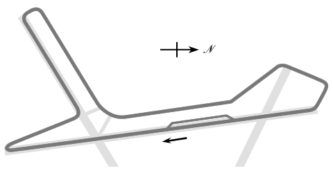
introduction => ' was a 2.8-mile airport course located 9 miles south of
downtown New Orleans, LA. It was used by the Delta Region SCCA in the 1950s.
This page was contributed by Guy Watney, Kansas City Region SCCA.
',
trackOffice => '',
mapService=>'Yahoo',
foodService=>'Yahoo',
hotelService=>'Yahoo',
timeZone => 'CST/CDT (-0600/-0500)',
trackMap => '
The track map was:
',
trackImage => '',
terraServerLink => '
http://terraserver.microsoft.com/image.aspx?T=4&S=12&Z=15&X=986&Y=4131&W=1
',
googleMapLink => '',
historicalNote => '',
weatherID => 'USLA0037',
weatherZIP => '',
officialWebSite => '',
schedulePage => '',
resultsPage => '',
ticketsPage => '',
gettingThere => '',
racersGuide => '',
hotLap => '',
workersGuide => '',
foodInsert => '',
hotelInsert => '',
TOCInsertLink1 => '',
TOCInsertText1 => '',
TOCInsertLink2 => '',
TOCInsertText2 => '',
TOCInsertLink3 => '',
TOCInsertText3 => '',
TOCInsertLink4 => '',
TOCInsertText4 => '',
TOCInsertLink5 => '',
TOCInsertText5 => '',
TOCInsertLink6 => '',
TOCInsertText6 => '',
offsiteTOCInsertLink1 => '',
offsiteTOCInsertText1 => '',
offsiteTOCInsertLink2 => '',
offsiteTOCInsertText2 => '',
offsiteTOCInsertLink3 => '',
offsiteTOCInsertText3 => '',
offsiteTOCInsertLink4 => '',
offsiteTOCInsertText4 => '',
offsiteTOCInsertLink5 => '',
offsiteTOCInsertText5 => '',
offsiteTOCInsertLink6 => '',
offsiteTOCInsertText6 => '',
&>