Cumberland Airport
Airport Road
Wiley Ford, WV 26767
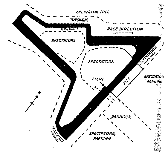
The map presently available is:
The airport was first used on May 20th, 1952. It was last used in 1971.
', reference1=>'AmericasSpeedways', reference1pages=>'355', weatherID => '', weatherZIP => '', weatherSource=>'weather.com', officialWebSite => '', schedulePage => '', resultsPage => '', ticketsPage => '', gettingThere => '', racersGuide => '', hotLap => '', workersGuide => '', foodInsert => '', hotelInsert => '', TOCInsertLink1 => '', TOCInsertText1 => '', TOCInsertLink2 => '', TOCInsertText2 => '', TOCInsertLink3 => '', TOCInsertText3 => '', TOCInsertLink4 => '', TOCInsertText4 => '', TOCInsertLink5 => '', TOCInsertText5 => '', TOCInsertLink6 => '', TOCInsertText6 => '', offsiteTOCInsertLink1 => 'http://www.nationalroadrally.com/tradition.html#1960', offsiteTOCInsertText1 => 'Brief history of the Cumberland Races', offsiteTOCInsertLink2 => 'http://www.nationalroadrally.com/photo/showgallery.php?cat=535', offsiteTOCInsertText2 => 'Photo Archive of Cumberland Races', offsiteTOCInsertLink3 => '', offsiteTOCInsertText3 => '', offsiteTOCInsertLink4 => '', offsiteTOCInsertText4 => '', offsiteTOCInsertLink5 => '', offsiteTOCInsertText5 => '', offsiteTOCInsertLink6 => '', offsiteTOCInsertText6 => '', &>