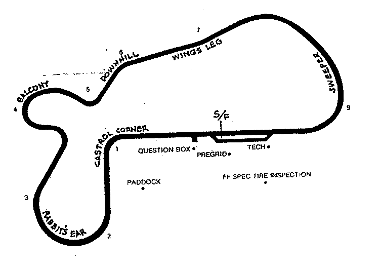
Willow Springs International Motorsports Park (aka "Willow Springs Raceway") is a complex which includes a 2.5 mile, 9 turn road course, a distinct, tighter handling course ("The Streets of Willow Springs"), a 3/8 mile dirt oval, a 1/4 mile paved oval, and a kart sprint course. Willow Springs is located near Rosamond, California.
"The Streets of Willow Springs" may be used in two different configurations, an 8 turn course with no straights and an 11 turn course with one straight. It is primarily used for workshops and clinics.
Much of the material on this page was contributed by Richard D. Buhl.
Last Updated: 2007-09-16
The road course opened on November 22nd, 1953 as a 2.5 mile oil dirt track. It operated in this form through 1958, and in 1960 and 1962. The road course was paved in 1962. The Streets of Willow Springs (1.8 mile road course) opened in 1996. A 1/4 mile pave dragstrip operated in 1962. The 3/8 mile dirt oval opened on April 12th, 1987, operating through 1995. It is apparently still used for vintage oval racing. A 1/4 mile dirt figure 8 course operated in the 1990s. The 1/4 mile paved oval opened on November 27th, 1993, operating through 1997, and reopening in 2002. Other names associated with the facility include Bill Huth International Motorsports Park, Kern County Speedway and WIllow Springs Speedway.
| Allan E. Brown, The History of America's Speedways: Past & Present. Comstock Park, Michigan: Brown, 2003 , ISBN 0931105617 , pp. 171. Order from National Speedway Directory |
The map presently available is:
For information on how these aerial images work, Click Here.
You may also wish to try using the Yahoo! Search as it may produce current news items.
The track is approximately 65 miles from San Fernando Valley.
From Los Angeles take I-5 North to Hwy 14 North.
Exit at Rosamond Blvd/Edwards AFB, and got West (left).
Continue West for approximately 6 miles.
Track is on your right. Can't miss it.
This collection is copyright 1996-2014 by NA Websites. All contributions copyright by their original author. Please contact the webmaster for permission to use any materials from this page.