Honda Grand Prix of St. Petersburg
25 Second Street North, Suite 160
St. Petersburg, Florida 33701
727-824-7223 (office)
727-896-8031 (fax)
Click Here for a map which shows the course which will be used for the 2005 race. I haven\'t published a thumbnail because I don\'t yet have permission to show the map on this site; the link goes to the map on the official web site.
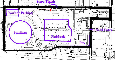
This map shows the Tropicana dome course (used 1996-97):
The Tropicana dome course was 1.6 miles in length and had 8 turns. The Start/Finish straightaway was 1st Avenue South, running from turn 8 (corner of 16th Street and 1st Avenue S) to turn 1 (corner of 8th Street and 1st Avenue S), crossing railroad tracks just before Start/Finish. After a 90 degree right turn, a one block long straight led to turn 2 (corner of 8th Street and 2nd Avenue S.) Another 90 degree right led to another one block straight on 2nd Avenue S, which then led to turn 3 (corner of Martin Luther King Street, formerly 9th Street, and 2nd Avenue South.) Turn 3 was a 90 degree left. The subsequent straight on Martin Luther King Street crossed the ground level infield entry on 3rd Avenue South, and pit in was between 3rd Avenue and and Turn 4 (corner of Martin Luther King Street and 4th Avenue S.) The pits made the same 90 degree right that the course took. The course continued to the corner of 4th Avenue South and 16th Street; this corner was turn 7. Turns 5 and 6 were the esses, a left-right combination just short of 1/2 way down this straight. The course then ran straight up 16th street to Turn 8, crossing railroad tracks again just before Turn 8.
', trackImage => 'The Google Map image is zoomed in on the construction of the pits (black asphalt) next to the runway which provides the front straight. The Yahoo! Map image is slightly newer and the sections of the course around the airfield are completed in it.
', terraServerLink => 'http://terraserver.microsoft.com/image.aspx?T=1&S=12&Z=17&X=423&Y=3840&W=1&qs=Central+Avenue%7cSt+Pete%7cFL&Addr=Central+Ave%2c+St+Petersburg%2c+FL+33701&ALon=-82.6333703&ALat=27.7712930', googleMapLink=>'http://maps.google.com/maps?f=q&hl=en&q=5th+Ave+SE+%26+Bayshore+Drive+SE,+Saint+Petersburg,+FL&sll=27.765635,-82.629622&sspn=0.004528,0.007274&ie=UTF8&ll=27.765602,-82.629611&spn=0.004528,0.007274&t=h&z=17&om=1', yahooMapLink=>'http://maps.yahoo.com/#mvt=h&q1=St+Petersburg%2C+FL&trf=0&lon=-82.630609&lat=27.767491&mag=2', historicalNote => 'The original circuit used was on the downtown waterfront. It was quite scenic, but disrupted things quite a bit. The original circuit was used for SCCA Trans Am events from 1985 through 1990.
The race was revived in 1996, and moved to a circuit around the Tropicana Dome (the baseball stadium). This circuit caused much less disruption but was a much less satisfactory race course. It was used in 1996 and 1997 for a late February SCCA Trans Am event, with support races that included US FF2000, SCCA World Challenge, Pro Spec Racer Ford, and Barber Dodge Pro.
After a layoff of several years, the race returned in 2003 as a ChampCar race in the Downtown/Waterfront area. The 2004 race was cancelled due to a dispute between promotors past, present and future. The race returned in 2005 under IRL sanction. Current contracts for the IRL race run through the 2009.
', weatherID => '', weatherZIP => '', officialWebSite => 'http://www.gpstpete.com/', schedulePage => 'schedule.cfm', resultsPage => '', ticketsPage => 'tickets.cfm', gettingThere => '', racersGuide => '', hotLap => '', workersGuide => '', foodInsert => '', hotelInsert => '', TOCInsertLink1 => '', TOCInsertText1 => '', TOCInsertLink2 => '', TOCInsertText2 => '', TOCInsertLink3 => '', TOCInsertText3 => '', TOCInsertLink4 => '', TOCInsertText4 => '', TOCInsertLink5 => '', TOCInsertText5 => '', TOCInsertLink6 => '', TOCInsertText6 => '', offsiteTOCInsertLink1 => '', offsiteTOCInsertText1 => '', offsiteTOCInsertLink2 => '', offsiteTOCInsertText2 => '', offsiteTOCInsertLink3 => '', offsiteTOCInsertText3 => '', offsiteTOCInsertLink4 => '', offsiteTOCInsertText4 => '', offsiteTOCInsertLink5 => '', offsiteTOCInsertText5 => '', offsiteTOCInsertLink6 => '', offsiteTOCInsertText6 => '', &>