Signifcant portions of the facility are still somewhat intact, and locals have been known to "take laps" on it.
Thanks to Alan Moore for the precise location data.
', historicalNote => 'A 1/2 mile dirt oval operated from April 3rd, 1955 through October 20th, 1957. A 1/10th mile dirt oval operated briefly in 1956. The 1/2 mile oval was paved from April 12th, 1958 through July 30th, 1965. A 1/4 mile dragstrip operated from August 2nd, 1958 through 1967; it used the front straight of the oval. A 1.5 mile road course operated from October 26th, 1958 through 1966. It used the dragstrip, return roads, and part of the oval.
', reference1=>'AmericasSpeedways', reference1pages=>'467', timeZone=>'EST/EDT (-0500/-0400)', elevation=>'65 feet', latitude=>'39.437187', longitude=>'-75.050097', mapService=>'Google', foodService=>'Google', hotelService=>'Google', terraServerLink=>'http://terraserver.microsoft.com/image.aspx?T=1&S=11&Z=18&X=1239&Y=10912&W=2', googleMapLink=>'http://maps.google.com/maps?f=q&hl=en&q=College+Drive+%26+Rutgers+Drive,+Vineland,+NJ&sll=39.440005,-75.04941&sspn=0.015809,0.029097&ie=UTF8&ll=39.437187,-75.050097&spn=0.007905,0.014548&t=h&z=16&om=1', weatherID=>'', trackMap=> '
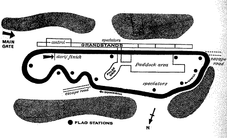
The road course map presently available is:
', TOCInsertLink1 => '', TOCInsertText1 => '', TOCInsertLink2 => '', TOCInsertText2 => '', TOCInsertLink3 => '', TOCInsertText3 => '', TOCInsertLink4 => '', TOCInsertText4 => '', TOCInsertLink5 => '', TOCInsertText5 => '', TOCInsertLink6 => '', TOCInsertText6 => '', offsiteTOCInsertLink1 => 'http://www.vineland.org/history/Vinelandspeedway/history/history.htm', offsiteTOCInsertText1 => 'A Short History of Vineland Speedway', offsiteTOCInsertLink2 => '', offsiteTOCInsertText2 => '', offsiteTOCInsertLink3 => '', offsiteTOCInsertText3 => '', offsiteTOCInsertLink4 => '', offsiteTOCInsertText4 => '', offsiteTOCInsertLink5 => '', offsiteTOCInsertText5 => '', offsiteTOCInsertLink6 => '', offsiteTOCInsertText6 => '', &>